Mt Vesuvius – Tickets, Hiking Tips and Eruption History
How Do I Get Tickets to Climb Mount Vesuvius?
Mount Vesuvius rises above the Bay of Naples as one of the most closely studied volcanoes on Earth. For visitors in 2025, the path to the summit runs through a straightforward but strictly regulated ticketing system that requires advance planning.
The volcano draws travellers who want to see the crater that buried Pompeii and Herculaneum in AD 79. But access to the rim is not a casual walk-up. The only route open to casual visitors, Trail No. 5 — known as the Gran Cono — requires a pre-purchased ticket bought exclusively online through the park’s official system.
Below is a snapshot of what first-time visitors need to know before they arrive at the mountain.
Book online via the official Vesuvius National Park site. Prices vary by season. The Gran Cono trail is the main route.
The AD 79 eruption buried Pompeii and Herculaneum. The most recent eruption was in 1944.
Vesuvius is an active stratovolcano under constant monitoring. Visits are permitted unless volcanic activity increases.
Located 9 km east of Naples and 20 km from Pompeii. Reachable by car, bus, or tour from Naples or Sorrento.
Key insights for planning
- Mount Vesuvius is the only active volcano on mainland Europe to have erupted in the last century.
- The AD 79 eruption was a Plinian event that released thermal energy 100,000 times greater than the Hiroshima atomic bomb.
- Over 3 million people live within the danger zone of a potential future eruption.
- The eruption of 1944 occurred during World War II and destroyed several villages but caused few casualties due to evacuation.
- Tickets must be bought online before arrival; on-the-day sales are not available for the Gran Cono trail.
- Prices typically fall between €10 and €15 for general admission, with some listings specifying €11.68 or €11.00 for the park entry portion.
- Time slots are enforced — one source states tickets are valid only from 40 minutes before to 100 minutes after the selected time.
| Attribute | Details |
|---|---|
| Elevation | 1,281 meters (4,203 feet) |
| Volcano Type | Stratovolcano (Somma-Vesuvius complex) |
| Last Major Eruption | 1944 (ongoing fumarolic activity) |
| Notable Historical Eruption | AD 79 (destroyed Pompeii, Herculaneum, Stabiae) |
| National Park | Vesuvius National Park (established 1995) |
| Total Trails | 11 trails totaling 54 km |
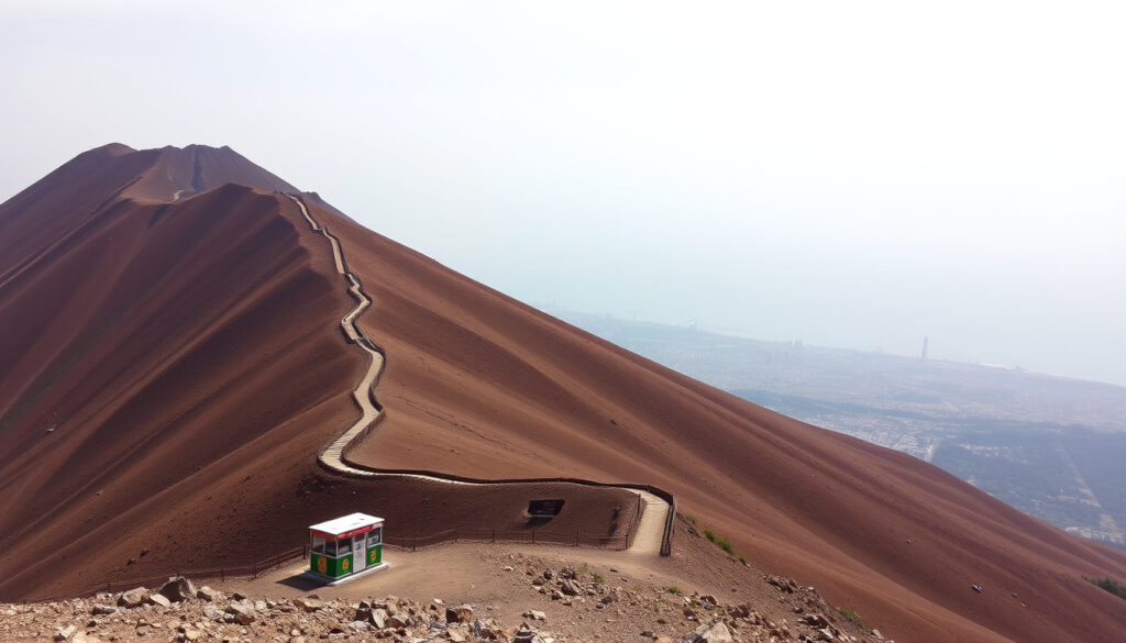
What the Gran Cono trail is like
The hike begins at Piazzale di Quota 1000, a parking area roughly two-thirds of the way up the mountain. From there, the path climbs steadily over rocky, gravelly terrain. It is commonly described as a moderate ascent with panoramic views over Naples, Pompeii, and the Bay of Naples.
Reported hike times for the round trip range from about 30–40 minutes to the rim on shorter estimates to 2–3 hours total including the full visit, depending on pace and route choice. Some tour products mention a first 30-minute step walk to reach the crater area from the entrance. Sturdy closed shoes are essential because the surface is dusty and can be slippery.
Opening hours by season
Crater-trail opening hours shift throughout the year. The following schedule has been reported by multiple sources: January, February, November, and December 9:00–15:00; March and October 9:00–16:00; April, May, June, and September 9:00–17:00; July and August 9:00–18:00. Access may be suspended for bad weather, strong winds, or weather alerts.
Temperatures on the trail can exceed 40°C in July and August. Shade is almost non-existent. Carrying water, sunscreen, a hat, and sunglasses is strongly advised. Starting early in the day offers cooler conditions and better visibility.
What Was the Mount Vesuvius Eruption of AD 79?
The eruption of AD 79 remains the defining event in Vesuvius’s recorded history. It was a Plinian eruption — the most violent kind — named after Pliny the Younger, who documented the catastrophe in letters to the historian Tacitus.
The scale of the disaster
On the afternoon of 24 August (or possibly 24 October, based on recent archaeological evidence), the volcano ejected a towering column of pumice, ash, and gas. Pliny the Younger described it as resembling an umbrella pine, “for it rose to a great height on a sort of trunk and then split off into branches.” Pyroclastic surges — fast-moving clouds of hot gas and volcanic material — swept down the slopes and buried the cities of Pompeii, Herculaneum, and Stabiae.
The thermal energy released during the eruption has been estimated at 100,000 times greater than the atomic bomb dropped on Hiroshima. Thousands of people died, though the exact number remains unknown. The ash that enveloped Pompeii preserved buildings, objects, and human forms in remarkable detail, creating one of the most important archaeological sites in the world.
The 1944 eruption and modern activity
Vesuvius has erupted many times since antiquity. The most recent eruption took place in 1944, during World War II. Lava flows destroyed the villages of San Sebastiano al Vesuvio and Massa di Somma. Because residents were evacuated in time, no civilian deaths were recorded. The eruption marked the end of a cycle of frequent activity — from 1631 to 1944, Vesuvius had erupted roughly every 30 years. Since 1944, the volcano has remained dormant, though fumarolic activity and seismic monitoring indicate it is still active.
The 1944 eruption was smaller than the AD 79 event. It produced lava flows and ashfall but did not generate pyroclastic surges of the same magnitude. The difference illustrates the range of behaviour Vesuvius can exhibit, from mild effusive eruptions to catastrophic explosive events.
Is It Safe to Visit Mount Vesuvius Now?
Vesuvius is an active stratovolcano — that fact is not in dispute. The question that many travellers ask is whether walking to its crater carries genuine risk.
Monitoring and alert systems
The volcano is under continuous surveillance by the Vesuvius Observatory (Osservatorio Vesuviano, part of Italy’s National Institute of Geophysics and Volcanology). Scientists track gas emissions, seismic activity, and ground deformation in real time. If the monitoring network detects significant changes, the Italian civil protection authorities can raise alert levels and restrict access.
Red Zone and evacuation planning
Approximately 3 million people live in the area surrounding Vesuvius. The Italian government has designated a “Red Zone” covering 25 municipalities that would be at highest risk in a major eruption. An evacuation plan exists, although its execution in a real emergency would face serious challenges due to population density and infrastructure constraints. For visitors, the practical reality is that the park permits hiking unless volcanic conditions deteriorate.
The Gran Cono trail closes during bad weather, strong winds, or volcanic unrest. Before travelling, check the official park site and weather forecasts. Park rangers on site have the authority to suspend access without notice if conditions become unsafe.
Practical safety advice for hikers
Wear sturdy closed shoes. Bring plenty of water, sunscreen, a hat, and sunglasses. Follow all instructions from park rangers. Parking near the trail is limited and may require a separate reservation — one source notes that parking is not allowed at Piazzale di Quota 1000 itself. Combining a visit to Vesuvius with Bourton-on-the-Water – Complete visitor guide for 2025 would require a very different itinerary, but for those staying in the Campania region, the volcano and the ancient cities of Pompeii and Herculaneum form a logical pair.
When Did Mount Vesuvius Last Erupt? A Timeline
The volcanic history of Vesuvius stretches back tens of thousands of years. Below are key events that shaped its modern reputation.
- c. 25,000 years ago — Formation of Mount Somma, the ancient volcano whose collapse created the caldera now occupied by Vesuvius.
- AD 79 — Catastrophic Plinian eruption buries Pompeii, Herculaneum, and Stabiae. Pliny the Younger documents the event.
- 203 — Eruption recorded during the reign of Emperor Septimius Severus.
- 472 — Sub-Plinian eruption deposits ash over much of Europe.
- 1631 — Major eruption kills thousands and alters the volcano’s cone.
- 1906 — Large eruption destroys villages in the Naples area.
- 1944 — Last eruption of Vesuvius during WWII. Lava destroys San Sebastiano al Vesuvio and Massa di Somma. No civilian deaths due to evacuation.
- 1995 — Vesuvius National Park officially established.
- Present — Vesuvius is dormant but monitored by the Vesuvius Observatory (INGV).
What Do We Know and What Remains Uncertain About Vesuvius?
Volcanic science has established certain facts with high confidence, while other questions remain open. The table below separates what is well understood from what is not yet clear.
| Established information | Information that remains unclear |
|---|---|
| Vesuvius is an active volcano and will erupt again. Confidence: very high, based on geological evidence and current monitoring. | The exact date of the next eruption is impossible to predict. Volcanic prediction is probabilistic, not deterministic. |
| The AD 79 eruption was a Plinian event that killed thousands. Confidence: very high, based on archaeological and literary evidence. | The scale of the next eruption remains unknown — it could be minor or major. Models exist, but the exact magnitude is uncertain. |
Why Does Mount Vesuvius Matter Beyond Its Tourist Appeal?
Vesuvius sits in the Campanian volcanic arc, formed by the subduction of the African tectonic plate beneath the Eurasian plate. Its history alternates between long dormancy and violent eruptions. The modern risk is managed by the Vesuvius Observatory, which tracks gas emissions, seismic activity, and ground deformation. The Italian government has an evacuation plan for the Red Zone covering roughly 25 municipalities. However, executing that plan in a real emergency would be difficult due to population density and infrastructure limits.
For those interested in coastal destinations with very different landscapes, the Weston Super Mare Beach – Guide to Tides, Access and Activities provides a useful contrast to the volcanic terrain of southern Italy.
What Do Sources and Witnesses Tell Us About Vesuvius?
Three sources provide widely cited perspectives on Vesuvius: a first-hand Roman account, an official park description, and a geological classification from a major museum.
“[describing the eruption cloud] its general appearance can best be expressed as being like an umbrella pine, for it rose to a great height on a sort of trunk and then split off into branches”
— Pliny the Younger’s letters to Tacitus, first-hand account of the AD 79 eruption.
“The Vesuvius National Park consists of 11 paths for a total length of 54 km of walkway.”
— Vesuvius National Park official website, visitor information and park facts.
“Vesuvius is a stratovolcano, built up by the layering of successive ash and lava eruptions over time. Its most violent explosions are known as Plinian eruptions.”
— American Museum of Natural History, geological classification of Vesuvius.
Summing Up: What Should a Visitor Take Away?
A trip to Mount Vesuvius combines a rare geological experience with a deep historical backdrop. Tickets must be bought online in advance. The Gran Cono trail is the only route to the crater, and the hike is moderate but requires proper footwear and plenty of water. The volcano is monitored constantly and is considered safe to visit under normal conditions. For the richest experience, many travellers pair the climb with a visit to Pompeii or Herculaneum, where the human story of the AD 79 eruption is preserved in extraordinary detail.
Frequently Asked Questions
How do you pronounce Mount Vesuvius?
Mount Vesuvius is pronounced /vəˈsuːviəs/ (vuh-SOO-vee-us) in English. In Italian, it is “Vesuvio” (veh-ZOO-vee-oh).
What is the difference between the AD 79 and 1944 eruption?
The AD 79 eruption was a massive Plinian event that buried entire cities with pumice and ash. The 1944 eruption was smaller, producing lava flows and ashfall, but no pyroclastic surges of the same scale.
Can you see Mount Vesuvius from Pompeii?
Yes. Mount Vesuvius is clearly visible from most of the Pompeii archaeological site, rising to the north. The distance between Pompeii and the crater is roughly 10 km.
Is there a map of Mount Vesuvius trails?
Yes. The official Vesuvius National Park website provides a trail map (PDF) of all 11 routes. The most popular is the “Gran Cono” path to the summit crater.
How long does the hike up Mount Vesuvius take?
The round trip typically takes 30–40 minutes to the rim on shorter estimates, or 2–3 hours total including the full visit, depending on pace and route choice.
What is the best time of year to climb Vesuvius?
Spring (April–May) and autumn (September–October) offer milder temperatures and clearer skies. Summer heat can exceed 40°C on the trail, and winter days are shorter with earlier closing times.
Are there guided tours to Mount Vesuvius?
Yes, many tour operators offer guided hikes that include transport from Naples or Pompeii and an audio guide. Some packages combine Vesuvius with Pompeii entry.
Is Mount Vesuvius connected to the train network?
No direct train goes to the summit. Visitors typically take the Circumvesuviana train to Pompeii or Ercolano, then catch a bus or taxi to the trailhead at Piazzale di Quota 1000.
More related posts
 Patricia Heaton – Biography, Net Worth, Husband, Children and TV Shows
 Queen Elizabeth – Biography, Cause of Death, and Legacy
 Celta Vigo vs Barcelona – 1-0 Win Extends Title Lead
 Walker Scobell – Age, Height, Parents, Movies, and 2026
 Lucrezia Millarini – Biography Age Husband Net Worth and Career
 Market Halls Oxford Street – Opening Hours, Menu and Guide
 50 Euros in Pounds – Current Rate and Trends
 Zara McDermott Louis Tomlinson – Timeline and Facts
